Las Vegas Strip Map – Hotels, Distances and 2025 Guide
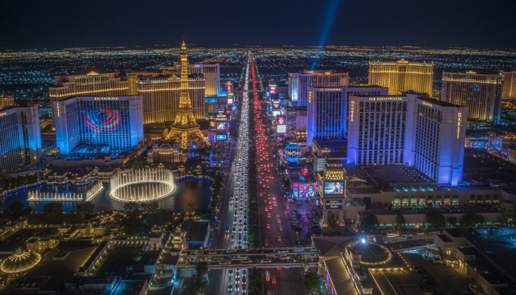
Navigating the Las Vegas Strip requires understanding its sprawling 4.2-mile layout stretching from Mandalay Bay to The STRAT Hotel Casino & SkyPod. The boulevard hosts dozens of major resorts, each occupying massive footprints that distort perception of walking distances. Accurate mapping tools have become essential for visitors attempting to coordinate show schedules, dining reservations, and cross-property exploration without underestimating transit times.
Contemporary Strip maps divide the corridor into three distinct operational zones: the North Strip trending toward luxury developments like Fontainebleau, the shopping-heavy Mid-Strip centered around Sands Avenue, and the South Strip anchored by Mandalay Bay and Luxor. Digital cartographers now overlay transportation layers including the Vegas Loop Tesla tunnels, monorail stations, and free inter-resort trams that alter traditional navigation strategies.
Whether seeking printable PDFs for offline reference or interactive mobile solutions with real-time updates, visitors face a landscape where resorts appear closer on paper than in physical reality. The following guide breaks down authoritative mapping resources, verified walking metrics, and digital tools reflecting 2025-2026 infrastructure developments.
Las Vegas Strip Map with Hotels and Casinos
Wynn Las Vegas to The STRAT. Fontainebleau Resort Casino fully operational.
Sands Avenue to Planet Hollywood. LINQ Promenade and High Roller access.
Mandalay Bay, Luxor, Excalibur, and Four Seasons. Includes The Shoppes mall.
4.2 miles total length. Average walking time 90 minutes end-to-end.
- Indoor walkways connect major resorts, allowing navigation without outdoor exposure
- Fontainebleau Resort Casino opened 2023, now fully operational on North Strip maps
- The STRAT marks the northern terminus at 4.2 miles from Mandalay Bay
- Resort footprints distort perceived distances; properties appear adjacent yet require 15-minute walks
- 2025 maps mark the Vegas Loop Tesla tunnel stations at Riviera, Central, and Encore
- BLVD Shopping Center (400,000 sq ft) replaces former Hawaiian Market in 2025 updates
- Interactive maps now include “Gone” hotels showing historical implosion sites like the 1995 Landmark demolition
| Landmark | Section | Key Feature | Connectivity |
|---|---|---|---|
| Wynn Las Vegas | North | Lake of Dreams | Vegas Loop Station |
| Fontainebleau | North | 67-story tower | Newest Resort |
| The STRAT | North | SkyPod Observation | Northern Terminus |
| LINQ Promenade | Mid | High Roller | Monorail Access |
| Crystals | Mid | Luxury Retail | Tram to Bellagio |
| Mandalay Bay | South | Shark Reef | Southern Terminus |
| Luxor | South | Pyramid Architecture | Tram to Excalibur |
| Excalibur | South | Medieval Theme | Free Tram Hub |
| Four Seasons | South | Non-Gaming Luxury | Via Mandalay Bay |
| BLVD Shopping | Mid | 400k sq ft Retail | Opening 2025 |
Detailed section breakdowns appear on LasVegasHowTo.com, which divides the Strip into North (Wynn to STRAT), Mid (Sands Avenue corridor), and South (Mandalay Bay cluster) segments. The site notes that multilingual photo versions accommodate international visitors.
How Long is the Las Vegas Strip? Walking Distances and Map
End-to-End Measurements
The Strip spans approximately 4.2 miles (6.8 kilometers) along Las Vegas Boulevard from the Mandalay Bay south entrance to The STRAT’s northern tower. This measurement follows the sidewalk routing along the boulevard rather than straight-line distance, accounting for the curved path past major resort frontages.
Walking times vary dramatically based on pace and engagement level. A continuous brisk walk covers the distance in roughly 45 minutes, while the average visitor requiring 90 minutes accounts for standard pedestrian traffic. Photographers, sightseers, and those entering casino attractions should budget two hours or more.
Practical Walking Considerations
Maps indicate indoor walkways connecting resorts like Excalibur to Luxor and Mandalay Bay, allowing segments of the journey to occur in climate-controlled environments. However, sections between major clusters require outdoor exposure along Las Vegas Boulevard sidewalks.
Summer temperatures exceeding 100°F create hazardous walking conditions. Updated 2025 maps mark drugstore locations for water resupply points. Winter months bring chilly evening temperatures requiring layered clothing despite daytime warmth.
Walking distance calculators on LasVegasDirect.com allow users to measure specific hotel-to-hotel segments rather than relying on the full 4.2-mile estimate.
Printable and PDF Las Vegas Strip Maps
Official Tourism Authority Resources
The Las Vegas Convention and Visitors Authority (LVCVA) publishes the definitive Strip Illustration Map, last updated May 2025. This downloadable PDF labels major properties including Luxor, Excalibur, and Mandalay Bay, alongside arterial roads like Frank Sinatra Drive, Dean Martin Drive, Paradise Road, and Koval Lane.
Specialized Print Formats
The LVCVA map explicitly notes it is not to scale, directing users to VisitLasVegas.com for additional resources. The PDF format allows offline access during travel when mobile data connectivity fails.
An alternative PDF is available through the NFR Experience portal, utilizing the same LVCVA cartography but optimized for rodeo event visitors with additional notation for temporary transit options.
Interactive Las Vegas Strip Maps and Apps
Comprehensive Digital Platforms
Easy.Vegas maintains the most comprehensive interactive implementation, marking hotels, Tesla tunnel stations, and historical sites like the imploded 1995 Landmark Hotel. The platform includes a “Gone” hotels layer showing former properties. While north-south scale remains accurate, the map compresses areas west of the Strip, requiring users to verify distances separately.
The Tesla tunnel network operates on a dual-access system. Blue-dot stations provide complimentary rides, while black-dot access points charge $4 to $6.25 per trip. Current stations include Riviera, Central Underground/Plaza, Encore, and Convention Center halls.
Specialized Navigation Tools
Strip Stumble (2025) marks drugstores, casino entrances, and indoor walkways for practical navigation. Dave Miller Gaming offers casino logo-based identification for quick visual recognition. Google Maps Enhanced (2025) now draws casino footprints directly into the base layer with precise walking markers.
Interactive maps maintain accurate north-south proportions but compress western areas. Users should verify walking distances through integrated measurement tools rather than visual estimation alone.
The Vegas.com Lounge Map provides hotel-focused visualization for both Strip and Downtown locations, while Easy.Vegas remains the most frequently updated platform for 2025-2026 construction status.
Historical Evolution of Strip Cartography
- — Landmark Hotel implosion added to historical map layers as “Gone” site notation
- — Fontainebleau Resort Casino opens, requiring major northern Strip redraws to reflect new 67-story tower
- — BLVD Shopping Center (400,000 sq ft) replaces Hawaiian Market site, adding retail corridor notation
- — Current mapping cycle begins with minimal construction disruption notation across all major platforms
What We Know and What Remains Variable
| Verified Information | Developing Situations |
|---|---|
| The Strip measures exactly 4.2 miles from Mandalay Bay to The STRAT | Specific tenant openings at BLVD Shopping Center continue through 2025 |
| Fontainebleau Resort is fully operational as of 2025 mapping | Future Vegas Loop expansion timelines remain unconfirmed |
| No major construction disruptions noted for 2025-2026 | Precise completion dates for additional tunnel stations pending |
| Vegas Loop operates with confirmed pricing at $4-$6.25 for paid stations | Long-term station additions beyond current seven locations uncertain |
Why Accurate Strip Mapping Matters
The disconnect between cartographic representation and physical reality stems from resort scale. A single property like Wynn Las Vegas or Fontainebleau occupies internal space equivalent to several city blocks, yet appears as a compact icon on mobile screens. This distortion leads visitors to schedule incompatible reservations, assuming a five-minute walk between properties that requires twenty minutes of transit.
Accurate maps now incorporate the Deuce double-decker bus routes and CX airport bus paths via I-15, offering alternatives to walking. For visitors coordinating evening entertainment, combining Live Music Near Me Tonight searches with verified transit maps prevents missed performances due to navigation errors.
Data Attribution and Methodology
Distance measurements and hotel operational status derive from 2025-2026 mapping updates published by Las Vegas Direct, Easy.Vegas, and the Las Vegas Convention and Visitors Authority. Walking time estimates account for average pedestrian flow rates along Las Vegas Boulevard sidewalks.
The Vegas Loop continues expanding with stations at Riviera, Central underground/Plaza, Encore, and Convention Center halls, offering both free blue-dot access and paid black-dot rides.
— Easy.Vegas Mapping Platform, 2025 Update
Strategic Navigation Planning
Successful Strip navigation requires selecting map formats matching specific needs: PDFs for offline reliability during device failure, interactive platforms for real-time Vegas Loop status, and specialized apps like Strip Stumble for amenity location. Visitors should verify distances using multiple sources rather than relying on visual proximity indicators, particularly when planning transportation between distant resorts or seeking local services like the Take 5 Car Wash – Locations Guide for vehicle maintenance during extended stays.
Frequently Asked Questions
Where can I find the Las Vegas Monorail on Strip maps?
Monorail stops appear on LasVegasDirect and VisitLasVegas interactive maps, marking stations from MGM Grand to Sahara Avenue with connection points at major resorts.
What is the best way to get around the Las Vegas Strip?
Options include the Deuce double-decker bus, Vegas Loop Tesla tunnels, free inter-resort trams, and walking. The Vegas Loop offers the fastest transit at $4-$6.25 for paid stations.
Do Strip maps show real-time construction closures?
Current 2025-2026 maps indicate no major construction disruptions. However, interactive platforms update more frequently than printable PDFs for temporary closures.
Why do casinos look closer together on maps than they are?
Resort footprints are massive. A casino may occupy several city blocks internally while appearing as a single icon on compressed map scales.
Are there free navigation apps specifically for the Strip?
Strip Stumble (2025) marks drugstores, casino entrances, and indoor walkways at no cost. Dave Miller Gaming offers casino logo-based identification.
More related posts
 Guru Nanda Pulling Oil: Benefits, Side Effects & How to Use
 Portugal vs Spain: Rivalry History, 2025 Final & Ronaldo
 Poison Tree Tattoo Meaning: Symbolism & Design Ideas
 DMDD: Symptoms, Treatment & Key Differences
 Shop Your Way Mastercard Discontinued: What to Know Now
 Dollar to Mexican Peso: 2025 Exchange Rates & Travel Tips
 Love Is Blind UK Latest: Couples Status and Season Updates
 Can Men Get Pregnant? Facts, Myths, and Future Possibilities